

Robots Can Run Marathons, So Why Is It Still So Hard to Reach the Front Desk?
Robots are becoming increasingly adept at movement. Quadrupedal robots climbing stairs and navigating obstacles is no longer novel. At the humanoid robot half-marathon held in Yizhuang, Beijing, this year, nearly four out of ten participating teams employed autonomous navigation.
But what if the finish line isn’t a track crossing, but the lobby of an office building?
In a navigation demonstration by Vbot (Vita Dynamics), the robot dog received the instruction: 'Meet at the front desk of Guotai Building.'
According to the task parameters, it had to start from the street, navigate a narrow passage between electric scooters and a wall, avoid pedestrians, bypass roadblocks, climb steps, and enter the building.
For a human, this is merely a routine path. For a robot, it must not only know the destination and handle constantly changing environments but also manage the transition between indoor and outdoor routes. Outdoor map data and indoor planning paths may originate from different systems, with inconsistent coordinate references and route representations. Furthermore, localization conditions can shift upon entering the building.
Being able to operate both outdoors and indoors is one thing; linking these two segments into a single continuous cross-environment task is another matter. In July 2026, researchers from the University of Michigan and others proposed NavVerse, which treats continuous indoor-to-outdoor navigation as a distinct evaluation problem. Their findings revealed that existing models still face challenges in locating exits, switching environments, and conducting long-duration target searches.
Different teams are pursuing various solutions. The Vbot research team focuses on integrating outdoor roads, building entrances, and indoor spaces into a single navigation task. This requires more than endowing the robot with separate indoor and outdoor navigation capabilities; it demands continuous alignment of route information and motion decisions during environmental transitions. To address this, the team developed VbotNav-0, designed for integrated long-range indoor-outdoor navigation.
This asynchronous cloud-edge dual-strategy framework builds on existing reference routes. The cloud component interprets the route and provides next-stage objectives, while the robot adjusts local trajectories continuously based on real-time perception. This allows the robot to understand where it needs to go next while simultaneously determining how to navigate the immediate surroundings.
Reaching the Front Desk: A Map Alone Isn’t Enough
In traditional navigation systems, outdoor routes are often generated by mapping software based on road networks, while indoor paths may come from spatial maps and path planners pre-built by the robot. Although both approaches guide the robot toward its destination, they do not necessarily share the same data formats or spatial references.
VbotNav-0 addresses this by using Route Tokens to unify the representation of indoor and outdoor reference routes. In simple terms, the system aligns pre-planned indoor and outdoor routes, extracts a short segment representing the immediate next steps, and converts it into local geometric information relative to the robot’s current position.
Beyond indicating direction and turning patterns, these Route Tokens carry metadata such as the route’s source, availability, reliability, and current progress.
This allows cloud-based navigation strategies to understand which segment to follow next, regardless of whether the robot is outdoors or inside a building.
However, having a route ready does not mean the robot can simply follow it blindly. This is similar to how human drivers use navigation apps: the map might instruct a right turn at the next intersection, but the driver must still handle unexpected situations on the road.
Consider a narrow sidewalk with a wall on the left, a row of parked electric scooters on the right, and pedestrians ahead. These obstacles may not require rerouting the entire journey, but they significantly impact how the robot should navigate the next few meters.
The green predicted trajectory overlaid in the first-person video shows the local forward direction selected by the model in response to these immediate environmental conditions.
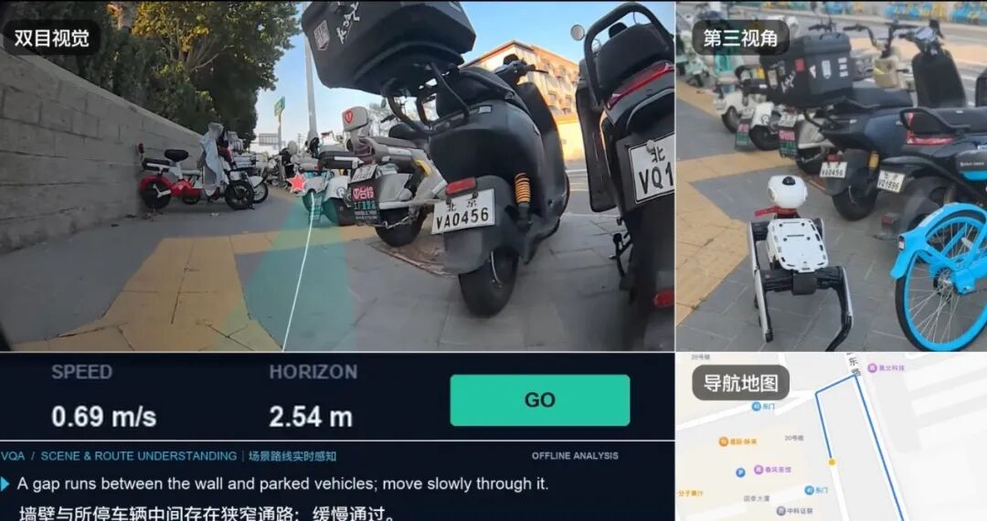
The spatial scope and latency requirements differ between cloud-based and edge-based processing. If every local obstacle-avoidance maneuver is delegated to a cloud large model, the robot must repeatedly upload data and wait for inference results; communication and computation delays can impair its responsiveness to environmental changes. Conversely, relying solely on the robot’s onboard systems for local reactions requires ensuring it consistently adheres to the global route rather than drifting off course after navigating around obstacles.
VbotNav-0 adopts a strategy where decision-making at different levels operates with distinct responsibilities.
The research team divides the navigation system into three tiers: System 2, System 1, and System 0. These can be understood as a 'navigator,' a 'driver,' and a motion control system responsible for executing specific actions.
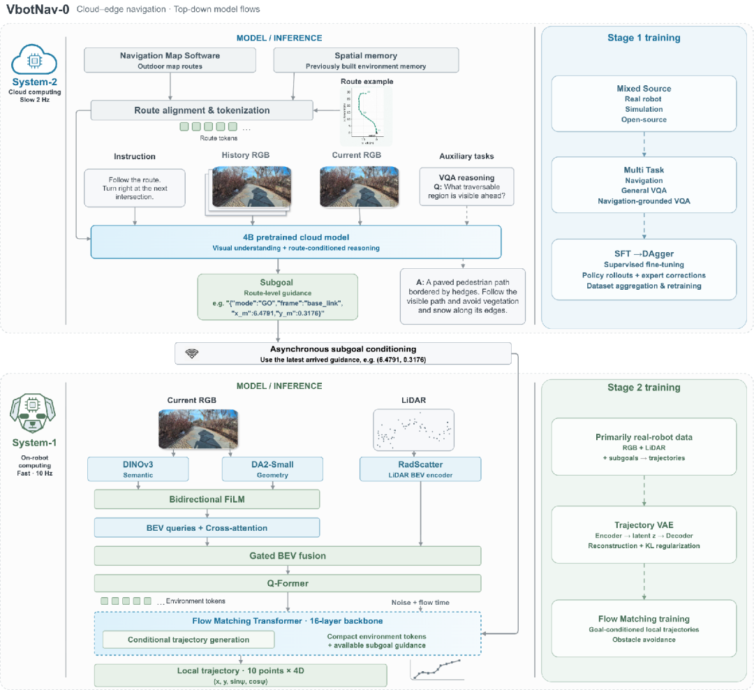
System 2 serves as the cloud-based 'navigator,' determining the next destination.
It employs a pre-trained multimodal model with approximately 4 billion parameters, integrating the robot’s current visual input, previously encountered scenes, user navigation instructions, and reference route information to determine the next phase of movement.
The model outputs a 'subgoal.' A subgoal is not the final destination of the entire task but an intermediate position along the way. For example, if the robot’s ultimate destination is the lobby of an office building but it is currently on the street, the cloud system might first provide a local waypoint directing it toward the building entrance. As the robot continues moving, the cloud updates its guidance based on refreshed environmental data.
System 1 acts as the 'driver' on the robot, responsible for determining how to navigate the immediate path.
It receives sub-goals from the cloud while ingesting the latest data from cameras and LiDAR to generate specific local motion trajectories.
In terms of technical implementation, VbotNav-0 uses DINOv3 to extract visual semantic features and DA2-Small to obtain geometric image features, which are then fused with spatial features from a bird's-eye-view map constructed by LiDAR. A 16-layer Transformer based on Flow Matching is subsequently used to predict a short future motion trajectory. The model outputs 10 trajectory points per inference, each containing relative position and orientation information.
This setup allows the cloud to simply provide the direction for the next phase, while the robot determines locally how to move toward that direction based on its current environment. If a temporary obstacle appears ahead, the overall route may not need to change; instead, the edge device can regenerate a local trajectory to adjust its immediate movement.
System 0 serves as the low-level motion controller.
It takes the trajectory predicted by System 1 and converts it into actual motion commands executed by the robot.
These three layers form a processing chain spanning route understanding, local trajectory planning, and motion control. However, cloud inference requires time, whereas the robot must continuously observe and act. How do these two components coordinate to ensure that local motion is not constrained by the update speed of the cloud?
This brings us to another core design of VbotNav-0: asynchronous cloud-edge dual-policy collaboration.
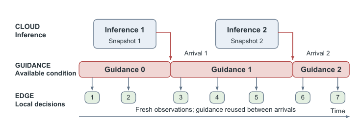
Under the configuration specified in the paper, the cloud updates route-level guidance approximately twice per second, while the edge device generates local trajectories about ten times per second. The underlying controller executes motion control at a higher frequency.
However, the key to asynchronous operation is not merely the difference in update frequencies. More importantly, it alters the information dependency between these components. In VbotNav-0, as long as existing cloud guidance remains valid, the edge device can combine new environmental observations to regenerate local trajectories even before new results are returned. For example, if the cloud has already directed the robot dog toward an office building entrance and a pedestrian suddenly appears along the way, the edge system can adjust local movement without waiting for the cloud to issue a new obstacle-avoidance command.
For consumer-grade robots intended to operate in real residential communities and shopping malls, this capability to continuously update local trajectories is more significant than simply pursuing peak performance.
Asynchronous collaboration must also address the issue of information staleness. Suppose the cloud captures an image as the robot approaches an intersection, but by the time the inference result returns, the robot has moved forward several meters. If guidance were selected solely based on the order of arrival, the system might rely on judgments generated from older environmental data.
Therefore, VbotNav-0 explicitly distinguishes three moments: the time the cloud acquires environmental information, the time the inference result arrives, and the time the edge device actually makes a decision.
According to the paper’s design, the edge device selects the guidance with the most recent source context from among the arrived and available results, preventing older, later-arriving information from overwriting newer navigation judgments.
Of course, this remains a mechanism at the system design level. Scenarios such as prolonged network disconnections or guidance failure still require validation through further real-world deployment.
Combining slower high-level reasoning with faster low-level action is already a research direction in embodied navigation. Studies such as NaVILA and Amap ABot-N1 have also explored various forms of hierarchical navigation architectures.
VbotNav-0 combines a unified indoor-outdoor reference route interface with an asynchronous cloud-edge dual-navigation strategy. Route Tokens convert routes from different sources into a common input format; the cloud strategy provides staged goals along the reference route, while the robot updates its local trajectory based on the latest perception.
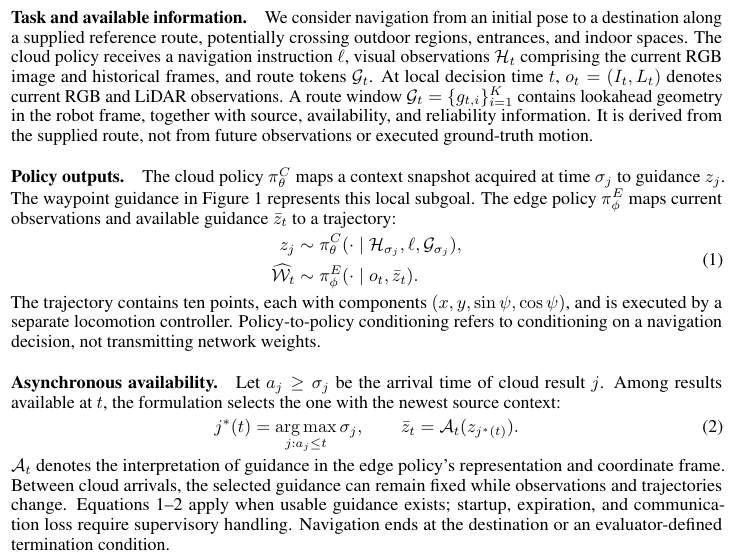
These steps—from route understanding to real-time obstacle avoidance and motion control—are organized within a single navigation architecture to support continuous movement across outdoor roads, building entrances, and indoor spaces.
This is what makes VbotNav-0 more noteworthy than studies focusing on isolated environments, path segments, or local obstacle avoidance: it treats the continuous execution of entire cross-environment routes as its system design goal.
However, having a well-designed architecture does not guarantee stable task completion. What happens if the robot takes a wrong turn, deviates from the route, or even paces back and forth in place?
What If the Robot Takes a Wrong Turn?
The research team divided training into two stages: first, training the cloud model to understand routes and predict sub-goals, and then training the robot side to generate local motion trajectories based on current perception.
Among these, the training of cloud-based strategies incorporates not only conventional supervised fine-tuning (SFT) but also two additional types of training signals worth noting.
One is DAgger-style corrective training.
Unlike approaches that only learn from pre-recorded expert demonstrations, the research team collects states such as yawing, incorrect turns, oscillating back and forth, and overshooting targets during model operation. It then uses expert correction data to train the model, exposing it to more scenarios where the robot deviates from the correct path.
The other is navigation-related Visual Question Answering (VQA) training, which focuses on strengthening the model's spatial understanding.
For a robot, recognizing that what lies ahead is a road does not necessarily mean knowing whether it can traverse it. VQA training involves tasks related to traversable areas, traffic rules, spatial positioning, and waypoint diagnostics, enabling the model to further learn how to judge whether the current environment matches the planned route.
To support this training, the research team constructed a dataset comprising over 650,000 navigation segments, with a cumulative duration exceeding 1,000 hours. Among these, real-world data accounts for more than 350,000 segments, while simulation data exceeds 300,000 segments. By environment, outdoor data comprises over 400,000 segments and indoor data over 250,000 segments, covering scenarios such as sidewalks, intersections, parks, shopping malls, offices, and homes.
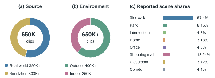
Cloud-based strategies primarily learn navigation and spatial understanding through mixed-source data, whereas edge-side trajectory strategies mainly use RGB, LiDAR, and local trajectory data collected by real robots to learn how to generate obstacle-avoidance trajectories based on sub-goals.
So, how does it perform in practice?
The paper compares VbotNav-0 with navigation models such as CityWalker, ViNT, NaVid, NaVILA, and SocialNav across 145 self-collected scenarios and 258 closed-loop evaluation rounds.
VbotNav-0 ultimately achieved a navigation success rate (SR) of 55.04% and a path-length-weighted success rate (SPL) of 55.03%. SR measures whether a task is completed successfully, while SPL further accounts for the efficiency of the paths taken in successful tasks.
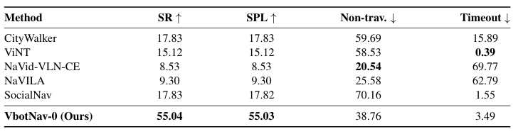
Under the same evaluation settings, CityWalker and SocialNav recorded the highest success rates among the compared models, both at 17.83%. VbotNav-0 outperformed this baseline group by 37.21 percentage points.
However, VbotNav-0’s task provided reference routes, and the tests used saved routes, rendered scenes, and unified closed-loop evaluation rules; these results cannot be directly equated to 258 real-world physical robot deployments. Meanwhile, although the compared models were connected to the same evaluator, they had not been retrained for this specific task, and the input information they received was not entirely consistent.
More revealing than the overall scores are the ablation studies in the paper, which better explain the impact of the training methodology.
The research team separately removed DAgger correction data and VQA joint training to observe how navigation performance would change.
The results show that removing DAgger caused navigation success rates to drop from 55.04% to 38.03%, a decrease of 17.01 percentage points; removing joint VQA training reduced the rate to 45.81%, a drop of 9.23 percentage points.
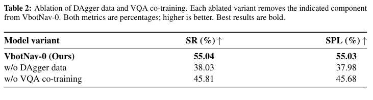
Under these model and testing conditions, both types of training signals contributed to final navigation performance. The larger decline observed when DAgger was removed indicates that, beyond learning correct routes, states in the training data that deviate from the path and require re-adjustment are equally important.
Specialized experiments on VQA provided more specific evidence. After relevant training, the model’s F1 score for identifying traversable area categories improved from 40.5% to 87.2%, while spatial region localization F1 rose from 12.4% to 59.1%.
The paper also presents a waypoint diagnostic case.
A set of candidate waypoints showed an overall offset relative to the correct route. The base model without VQA training incorrectly deemed negative-direction coordinates unreasonable; the trained model, however, judged that the entire set of waypoints had shifted by approximately 5.81 meters, closely matching the reference answer of 5.82 meters.
Clearly, what the model needs to understand extends beyond merely identifying objects in its immediate view to assessing whether the route aligns with spatial positions.
However, a single case does not represent overall capability. Although VQA training increased the model’s waypoint diagnostic pass rate from 3.5% to 45.0%, there remains a significant gap toward reliably diagnosing various route issues. In the main navigation experiment, 38.76% of rounds predicted by VbotNav-0 ended in areas labeled as non-traversable. There is still room for improvement in judging whether local targets are accessible. Of course, this metric does not equate to the actual collision rate of physical robots.
These experiments support VbotNav-0's navigation performance, as well as the roles of error-correction training and spatial semantic supervision. However, the paper has not yet sufficiently validated the independent benefits of the asynchronous mechanism under complex communication conditions. There is still a gap between success in specific evaluations and long-term stable operation in real-world environments.
From Roads to Reception Desks: What Robots Still Need
"See you at the Guotai Building reception desk." For humans, this is just an ordinary arrangement.
For robots that can currently only complete defined tasks in specific environments, entering buildings from outdoor roads and reaching designated indoor locations represents a typical requirement if they are to undertake more complex future work such as campus patrols, building services, and cross-scenario deliveries.
VbotNav-0 focuses its research on this continuous mobile task. It attempts to enable robots to use the same navigation architecture to complete cross-environment movement under existing reference routes.
Transitioning from technical demonstrations to real-world use requires robots to face constantly changing environments. A clear road today may have construction barriers tomorrow; the same route may require adjusted movement patterns due to changes in foot traffic.
In this regard, Vbot already has a foundation of practical usage with consumer-grade products. In May 2026, Vita Dynamics launched mass production and delivery of its first robot dog, "Big Head." According to data made public in August, the product had cumulatively accompanied users for 23,700 kilometers and completed four OTA updates over the past three months.
These real-world usage experiences provide opportunities for robots to identify new problems and accumulate feedback. How effectively issues encountered during actual operation can be converted into training data, and how model iterations can improve navigation capabilities, will determine whether robots can perform tasks consistently and stably over the long term.
Of course, VbotNav-0 still relies on existing reference routes. Challenges such as entering unfamiliar buildings without maps, reliably completing indoor-outdoor localization handovers, and handling prolonged communication anomalies also require further resolution.
Over the past few years, robots have continuously pushed the boundaries of what people imagine regarding mobility. Yet as they begin to enter actual workplaces, we are still waiting for a simple 'see you at the front desk' to be met with the robot's ability to walk there on its own.